Property Information Report
19 Glenmore Avenue
Farnworth, Bolton, BL4 0JB
Last Sold - Mar, 2004


Description
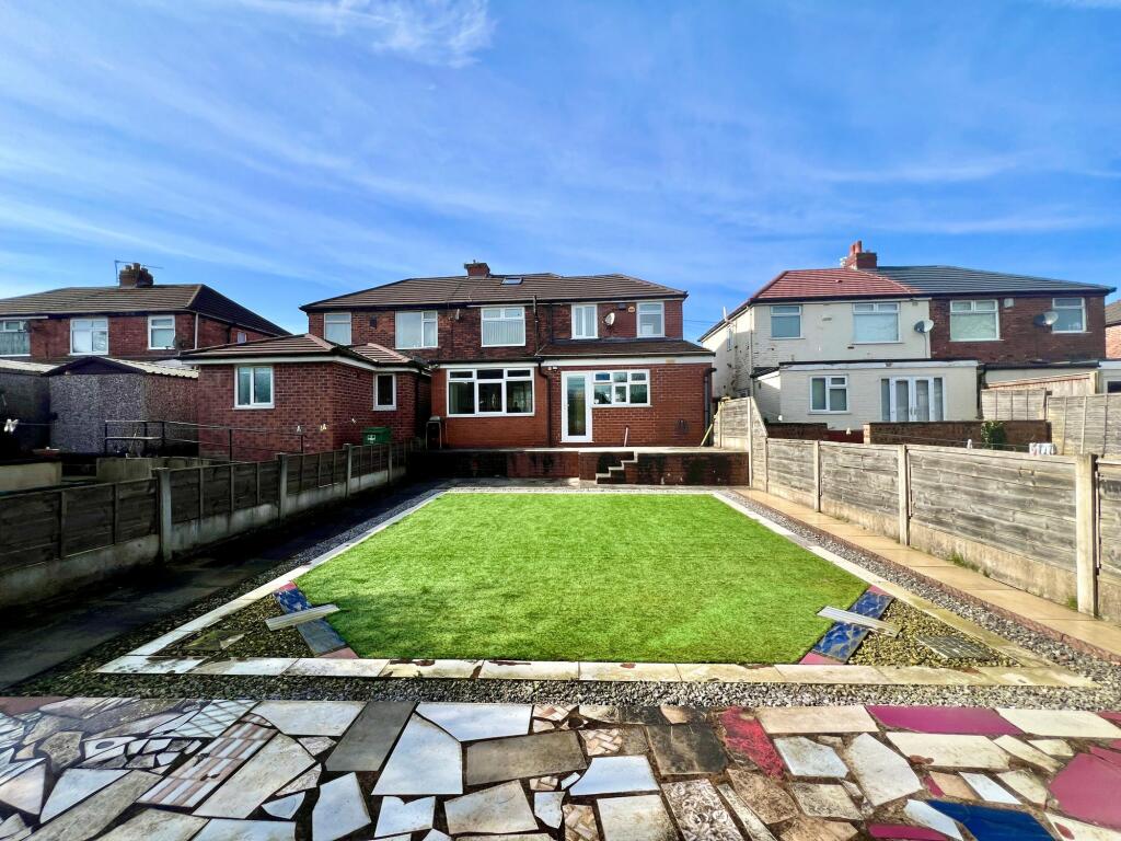
A VERY SPACIOUS EXTENDED SEMI DETACHED HOUSE PRESENTED IN EXCELLENT CONDITION. On the ground floor this ideal family home offers two reception rooms, a large kitchen, a shower rooms, a utility room, a hallway and porch. On the first floor there are four bedrooms and and a family bathroom. The loft has been converted and offers further living space. The house has gas central heating and windows are UPVC double glazed. Externally, there is a good size low maintenance garden to the rear and a paved driveway to the front of the house. There a local schools, shops and transport links. COULD THIS WONDERFUL FAMILY HOME BE THE ONE FOR YOU? CALL TO BOOK A VIEWING.
Key Facts
About Us

About Us
Passionate about what we do. Here to serve the people of Salford and Greater Manchester and dedicated to helping you find your perfect home. Meet the multi-award winning team of property professionals at Hills.
Generate a full report on your own property including an instant estimated valuation.
Title Plan
 Contains OS data © Crown copyright 2024
Title Information
Details provided by the Land Registry
- Title Number
- GM71966
- Plot Size
- 0.06 acres (245 sq metres)
Street View
EPC
 No EPC data available for this property.
Hills Salfords Estate Agents
Schools
| Name | Type | Postcode | Distance | Rating |
|---|---|---|---|---|
| Mount St Joseph | Secondary | BL4 0HU | 0.17 km | Good |
| Lord's School | Independent, Primary, Post 16 | BL3 2EF | 0.45 km | Good |
| Harper Green School | Secondary | BL4 0DH | 0.78 km | Not rated |
| Highfield Primary School | Primary | BL4 0AP | 0.86 km | Good |
| Our Lady of Lourdes RC Primary School | Nursery, Primary | BL4 0BP | 0.86 km | Good |
Transport
Bus Stops & Stations
Details provided by Department for Transport
| Name | Distance |
|---|---|
| Minerva Road | 0.16 km |
| Bishops Road | 0.17 km |
| Greenland Road | 0.19 km |
| Bradford Road | 0.30 km |
| Mount St Joseph School, School Grounds | 0.31 km |
Train Stations
Details provided by Department for Transport
| Name | Distance |
|---|---|
| Moses Gate Rail Station | 1.23 km |
| Bolton Rail Station | 2.11 km |
| Farnworth Rail Station | 2.22 km |
| Kearsley Rail Station | 3.27 km |
| Walkden Rail Station | 4.30 km |
Nearest Motorway
Details provided by Department for Transport
| Name | Distance |
|---|---|
| M61 | 2.29 km |
Coverage
- Average Broadband Speed:
-
4mb Basic
-
57mb Superfast
-
1000mb Ultrafast
-
1000mb Overall
- Mobile Coverage:
-
EEGood
-
O2Good
-
ThreeGood
-
VodafoneGood
Important Notice - This report is intended for general informational purposes only and should act only as a guide. The report is produced automatically on behalf of Hills - Hills by Street Insights, a product of Street Systems Ltd. Street Systems maintains and aggregates data from multiple public data sources and whilst every effort is made to keep information up to date and accurate, we make no representations or warranties of any kind about the accuracy, reliability or completeness of the information contained within this report for any purpose. Any reliance you place on the data contained within this report is strictly at your own risk. In no event will Hills - Hills or Street Systems Ltd be liable for any loss or damage including without limitation, indirect or consequential loss or damage, or any loss or damage whatsoever arising from loss of data or profits arising out of, or in connection with, the use of this report.
This report contains public sector information licensed under the Open Government License v3.0
Transaction data and HPI data is produced by HM Land Registry. Crown copyright and database rights 2024